📥 Download Lab Worksheet (Offline Option)
Use the link below to access the worksheet that must be submitted in Brightspace:
🎯 Learning Outcomes
- Describe the basic characteristics of Earth's three layers: crust, mantle, and core
- Define the lithosphere and asthenosphere
- Understand how hotspots create volcanic island chains
- Calculate the rate of movement of the Pacific Plate using real data
- Apply rate calculations to determine plate movement over time
- Compare plate movement rates across different hotspots globally
📚 Background: Earth's Layers and Plates
Earth's Structure
The Earth is composed of three primary layers:
- Core: The innermost layer made of iron and nickel. The outer core is liquid, while the inner core is solid due to intense pressure.
- Mantle: A thick layer of hot, molten rock (magma) that flows slowly like very thick asphalt. About 1,800 miles thick!
- Crust: The thin, rigid outer layer where we live. There are two types: oceanic crust (beneath oceans, 4-7 miles thick) and continental crust (beneath land, 20-25 miles thick).
- Lithosphere: The rigid layer composed of the crust and the top part of the upper mantle. It's broken into plates.
- Asthenosphere: The "weak sphere" - a softer, flowing layer beneath the lithosphere that allows plates to move.
- Tectonic Plates: Large pieces of the lithosphere that fit together like a puzzle and are constantly moving.
Oceanic vs. Continental Crust
| Property | Oceanic Crust | Continental Crust |
|---|---|---|
| Age | 70-180 million years old | Up to 3 billion years old |
| Thickness | 4-7 miles | 20-25 miles |
| Density | 3.0 g/cm³ (denser) | 2.7 g/cm³ (lighter) |
| Composition | Mostly basalt (dark volcanic rock) | Mostly granite (lighter rock) |
What is a Hotspot?
A scientist named J. Tuzo Wilson noticed that some volcanoes occur in lines or rows. His theory was that volcanoes form at small melting areas in the mantle called "hotspots" where magma plumes break through the crust.
Global Hotspots
Famous hotspots around the world:
World Hotspot Map
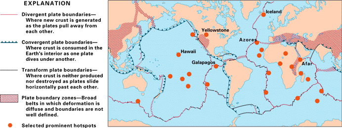
Map credit: U.S. Geological Survey showing global distribution of hotspots and plate boundaries
| Hotspot | Location | Plate Moving Over It | Average Rate (cm/yr) |
|---|---|---|---|
| Hawaiian | Pacific Ocean | Pacific Plate | 10.6 cm/yr |
| Yellowstone | Wyoming, USA | North American Plate | 2.5 cm/yr |
| Iceland | North Atlantic | Divergent boundary | 1.9 cm/yr (spreading) |
| Galápagos | Pacific Ocean (Ecuador) | Nazca Plate | 4-5 cm/yr |
📚 Additional Resources: Learn More About Hotspots
Click on each card to learn more about hotspots from different perspectives:
Hot Spot Volcanism
education.nationalgeographic.org
Comprehensive educational resource explaining hotspot theory, mantle plumes, and how volcanic chains form. Includes examples from Hawaii, Yellowstone, and Iceland with emphasis on plate movement over stationary hotspots.
Visit Resource →Hotspots - Geology
nps.gov/subjects/geology
Explores hotspots in U.S. National Parks including Hawaii Volcanoes and Yellowstone. Compares oceanic vs. continental hotspot tracks and explains how volcanic features differ based on crustal thickness.
Visit Resource →5.16: Hot Spots
geo.libretexts.org
Academic textbook chapter covering hotspot theory, mantle plume hypothesis, and alternative explanations. Discusses scientific debates about whether hotspots are truly "hot" or simply areas of lithospheric weakness.
Visit Resource →What is a hotspot volcano?
oceanexplorer.noaa.gov
Ocean-focused explanation of hotspot volcanism with emphasis on submarine volcanoes, seamount chains, and Pacific Ocean examples. Describes how hotspot tracks help reconstruct plate motion history.
Visit Resource →Discovering the Deep: Remote Pacific MPAs
oceanexplorer.noaa.gov
Deep-sea exploration of Pacific seamounts and volcanic features. Documents ROV dives exploring hotspot-generated seamounts, their biology, and geology in remote marine protected areas.
Visit Resource →Deepwater Wonders of Wake: Geologic Overview
oceanexplorer.noaa.gov
Detailed geologic context of West Pacific seamounts formed by hotspot volcanism. Explains how volcanic chains record plate movements over millions of years and discusses manganese crust formation on old seamounts.
Visit Resource →🌊 Interactive Resource: NOAA Hotspot Volcano Explanation
Explore this interactive resource from NOAA Ocean Exploration:
🎲 Part 1: Make Your Prediction!
🏆 Challenge: How Far Has the Plate Moved in Your Lifetime?
Before we do any calculations, let's make this interesting! How far do you think the Pacific Plate has moved during your lifetime?
Write your guess in FEET:
First, we need to calculate the rate of plate movement. Remember that rate equals how far something moved divided by time (like miles per hour). Scientists report plate movement in centimeters per year (cm/yr). Once we know the rate, we can multiply by your age to find out how far the plate has moved!
Rate = Distance ÷ Time
🗺️ Part 2: Measure the Hawaiian Islands
The map below shows the main Hawaiian Islands. The oldest islands are furthest to the northwest, and the youngest island (Hawaii/Big Island) is in the southeast—it's still forming today!
- Hawaii (Big Island): 0 years old (currently over the hotspot!)
- Molokai: 1.8 million years old
- Oahu: 3.3 million years old
- Kauai: 5.6 million years old
Interactive Hawaiian Islands Map
Choose a background for the interactive map:
Or paste your own image URL:
📏 Click on Hawaii (Big Island), then click another island to measure the distance!
Click on Hawaii (Big Island) first to start measuring.
🧮 Part 3: Calculate Plate Movement Rate
Now let's calculate the rate at which the Pacific Plate has been moving! Fill in the table below with your measurements.
| Island | Distance from Hawaii (km) | Age (million years) | Rate (km/million years) |
|---|---|---|---|
| Molokai | 1.8 | ||
| Oahu | 3.3 | ||
| Kauai | 5.6 | ||
| AVERAGE RATE | |||
Convert to Centimeters per Year
Scientists usually express plate movement in centimeters per year. Let's convert!
Why? Because 1 km = 100,000 cm, and 1 million years = 1,000,000 years.
So: (km/million years) × (100,000 cm/km) ÷ (1,000,000 years) = (km/million years) × 0.1
🎯 Part 4: How Far in Your Lifetime?
Now for the moment of truth! How far has the Pacific Plate moved during your lifetime?
We'll multiply your rate (in cm/yr) by your age in years to get the total distance in centimeters!
| Average Rate (cm/yr) | Your Age (years) | Distance (Rate × Time) |
|---|---|---|